Sedimentary rocks, those made of little crumbled bits of pre-existing rocks, are all originally deposited in horizontal layers (or very close to it). This is one of the most important principles in understanding how to assign ages to rocks.
The problem is, that most rock layers that we see are anything but perfectly horizontal. Take a look at this, for example:

This is a photo from Siccar Point in Scotland shows two generations of rock layers. Both sets of rock layers were originally deposited horizontally, but they have been subsequently tilted and eroded. You can get the whole story of how these rocks got this way by looking here.
For the moment, we’re just interested in understanding how we can describe this ’tilty-ness,’ and illustrate it on a two-dimensional map.
To do this, geologists use “Strike and Dip.” (I swear, it sounds like a dance move.)
Even though ‘Strike’ is the first word there, it is the hardest part to conceptualize, so we’ll start with ‘Dip.’ Dip is easy.
Dip is the direction the rock tilts. If you put a drop of water or a marble on the rock, whatever way it rolls is the dip direction. We can measure the direction with respect to North using a compass. We can draw a line in the dip direction on a map.
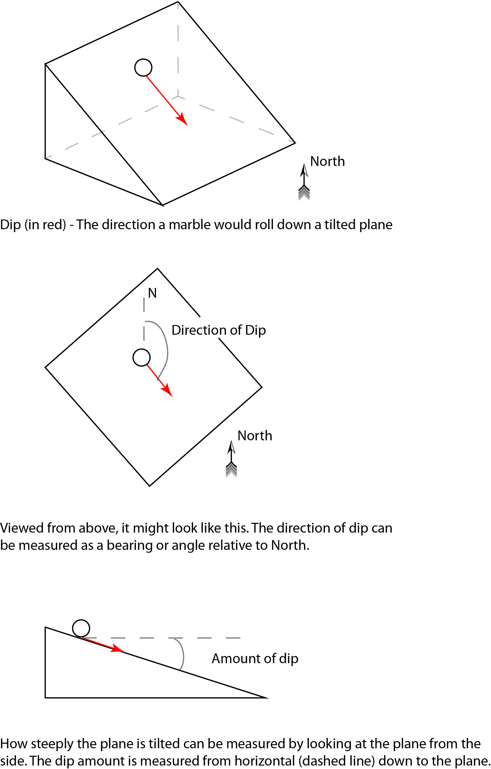
Strike is more difficult to conceptualize. It is the bearing of a horizontal line that lies on the inclined plane. It’s easier to imagine, however, when you realize that it is perpendicular to the dip direction. Always.

On geologic maps, we need to show the orientation of tilted (inclined) beds (which is three dimensional) on a two-dimensional surface. To do this, we use the strike and dip symbol. This is basically a ‘T’ where the top of the T is plotted in the strike direction, and the base of the T is plotted in the dip direction. A number next to the base of the T is the dip amount.

Strike and dip are fundamental measurements taken by geologists in the field. Often, they are measured on bedding surfaces of sedimentary rocks, but can also be measured on faults, cracks, and veins. In any of these cases, it is important for the geologist to be able to represent the surface that is being measured on a two-dimensional map. This is done using the strike and dip symbol.
Hopefully this little introduction can help de-mystify one of the many things that geologists must do every day.
Any questions?
