This is a little mini-rant. Remember this post from last week, in which I explain that rivers can, in fact, flow north? I was working on a little post for today describing the concept of knickpoints and rivers. It turns out Niagara Falls is a great example of this.
It turns out also that most likely all the satellite views of Niagara Falls you’ve seen on the Internet are oriented wrong.
Try this. Do a Google image search for Niagara Falls satellite images. Here, I did it for you.
Here’s the first hit from the image search:
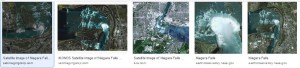
Notice how in almost all of these images, Horseshoe Falls opens to the south (sometimes southwest, sometimes southeast).
Now, go to Google Maps and search for Goat Island, Niagara Falls, NY. Here, I did this for you, too.
Notice how on Google Maps, where north is always toward the top of the page, Horseshoe Falls opens to the north. The Niagara River flows from right to left along the bottom of the image, then turns to flow toward the top of the image after going over the falls.
Yes folks, the Niagara River flows north over Niagara Falls.
But, because people are uncomfortable with northward flowing rivers, in almost all cases, the image is rotated to make the river flow in a more comfortable direction.
And thus, the notion that rivers cannot flow north is perpetuated.
This whole issue could be avoided if people posting these photos would either 1) put north toward the top of the page, or 2) put a north arrow on their image. These things would go a long way to fix some common misconceptions.
Thus ends my rant.

I’m sorry, Penny, but the Goat Island picture is clearly wrong, for it has Canada south of the United States. Check it and see! 😉
LikeLike
You’re impossible, Kurt. Canada is also north of Goat Island. I think it just didn’t want the goats. 😛
LikeLike
Hear, hear! I’m pretty much always in favor of accurate over aesthetic. If I want a pretty picture, I’ll get one. WHERE DOES THE WATER GO?!?
Thank you for clearing that up. =)
LikeLike