One of those things we do as geoscientists is try to figure out if the rocks in one place are the same as the rocks in another place. While it seems a very easy question to ask, it’s not so easy to answer.
This determination of ‘sameness’ is called correlation. But before we can do any correlating, we have to get more specific in our question. Do we want to know if rocks here and there are the same age, or do we want to know if they represent the same environment?

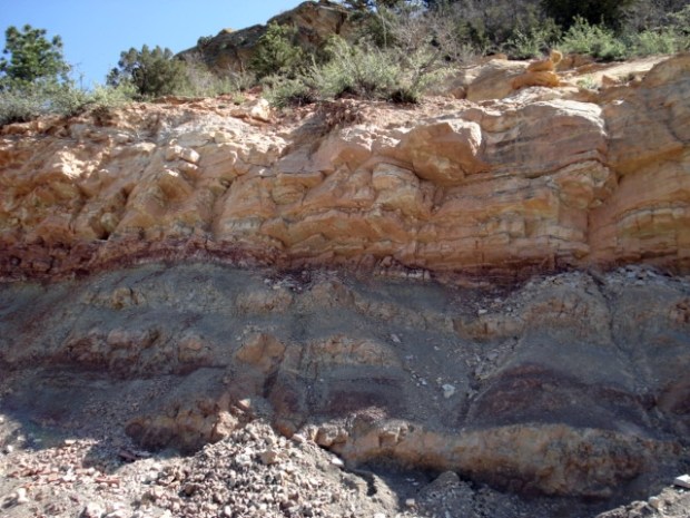
Environmental correlations are by far the most common, because they’re a little more straightforward. You see, typically two rocks deposited in the same environment will look the same. We can correlate the same rock type from place to place quite easily on foot, for with aireal photos, or these days with images from Google Earth. These distinct rock types are fairly easy to distinguish and trace with even my poor eyesight.
The term we use to describe the characteristics of rock that represent a particular environment is facies. We can say a rock represents a beach facies. Perhaps it is a reef facies. Or the facies is a delta that is growing into a lake.
Rocks tend to form in layers that can readily be traced (correlated) from place to place. We have a term for such a rock layer that’s easy to identify and can be shown on an ordinary map. This is called a formation. We can correlate single formations over huge areas. The famous Morrison Formation is found throughout Colorado, Wyoming, New Mexico, Arizona, Utah, Montana, and elsewhere, for example. It represents environments that were affected by rivers and lakes carrying sediment from the growing Rocky Mountains into a seaway that ran through the central part of North America. The similarity in environments makes it easy to trace around.
Ankyman CC BY-SA 3.0
What this tells us is that when we’re making correlations by rock type (either on the scale of formations or based on smaller layers within a formation) we’re correlating environments, or facies.
Rock (or lithologic) correlations like those described above are interesting to make, and have their use. However, despite the fact that some formations can cover huge areas, we know that a single environment does not cover the entire Earth all at once. There are thousands of different environments existing all at the same time. For example, while the Morrison Formation was being deposited in Colorado during the Jurassic Period, and dinosaurs were running around and doing dinosaur-y things, there was an ocean in Nebraska.
The other kind of ‘sameness’ we might like to correlate is time. What was happening in different places on Earth during specific periods of time?
We use radiometric dating techniques when possible to help determine the ages of rocks. One thing we often find is that a single formation can be different ages depending on where you are. The facies may have moved over time. But how can this be?

The above example is a little extreme, but it makes the point: if you correlate rock type (facies or lithology), you might not be correlating time, and vice versa.
What can you do about this?
You can’t do much, other than be aware of it. Absolute dating methods will help correlated ages, and careful mapping and description can help correlate rock type.
Sometimes you can use fossils to help, but you must understand the fossil organisms for this to be effective. Some organisms prefer a particular environment, so can’t really be used for correlating age. But an organism that has a very broad distribution, and is not limited to a specific environment, might be great for assigning ages. Such a fossil is called an index fossil.
Correlation is not a simple exercise, but it is a necessary one for understanding the events that have taken place on Earth in the remote past. It is important to make sure you are clear on what you are correlating before you begin.
